In the north part of Pindos mountain, the mountainous bulges of Trapezitsa (2022 m), Timfi (Gamila) (2497 m), Smolikas (2637 m) and Lygkou (2204 m) prevail.
Here also exists, Vikos and Aoos gorge, Valia Kalnta, as well as the steep slopes. Together with Smolikas, Timfi operates as determinant regulator of the water balance, as they both supply water to the most important rivers of the area, Aoos and Voidomatis.
Climate: The climate influences the morphology and the operation of the ecosystems (vegetation types, fauna and flora species) of N. Pindos.
The area is characterised by high annual rainfall (800-2200cm) and dense snow that falls 7-9 months per year.
The average temperature of the warmest month is 29.7 Co and the average temperature of the coolest month is -9.0 Co.
Water: The hydrographic network of the area of N. Pindos National Park presents a great interest, with its rivers and confluents that run the mountainous area.
Aoos has its source in Mavrovouni Metsovou. I it runs the valley, whose name was taken by the river, known as “Lakka Aoou” and, before reaching Konitsa basin, it passes through the channels that are formed by the mountainous bulges of Trapezitsa, Smolika and Timfi. In Aoos contributes a large number of streams and flumes which supply it with a large amount of spring and rain water.
Voidomatis (from the Slavic “Vointo-mat” which means “good water”) is supposed to be one of the cleanest rivers in Europe. Its source supply is Vikos gorge, in the foothill of Vikos village through underground springs that gush at this point and supply it continuously. Voidomatis is confluent of Aoos, with whom it meets in Konitsa plain and collects the water of the central and western part of Timfi.
Natural Environment:
Ecosystems
N. Pindos presents one of the greatest indicators of habitat diversity in mountainous Greece.
Only in the area of Zagori there have been recorded 34 habitat types, 24 of which present special interest and that is why they are included in the Community Directive 92/43 for the “conservation of habitats and flora and fauna species”.
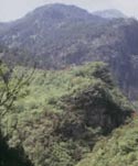
Forest vegetation covers 80% of the area. At lower altitudes vegetation with Mediterranean elements appears (evergreens- broadleaved), the zone of oaks follows, and at the greater altitudes coniferous trees are dominant, with most characteristic the black pine, while even higher trees of beech and white pine appear. The pasture and steppe-like areas appear higher at altitude then the forest boundaries.
Priority habitats that are protected are the Forests of Black Pine, the mixed Greek forests of beech- Black Pine and the broadleaved oak forests with Black Pine.
Flora: The area is supposed to be one of the richest, as far as species number is concerned. In total, there have been recorded 1700 flora species and subspecies. Amongst them, 6 local endemic species are included, three of which exist in Aoos gorge and three in the alpine area of Timfi. In the area, 35 Greek endemic species also exist, and 121 Balkan endemic.
Fauna: The dimension of the area and its dominant forest and mountainous character secures ideal conditions for the survival of a large diversity of forest-living mammals, such as the brown bear, the rod dear, the chamois, as well a large number of bird species. The large undisturbed parts of the forest, as well as the diversity of food supplies, cover their vital needs and their demands (shelter, food, reproduction).
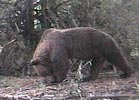
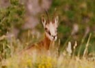
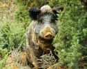
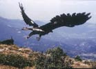 From the left: bear, chamois, wildboar and Aquila chrysaetos.
The type of human activities that were developed traditionally in the area of N. Pindos offered additional food resources to the bear and the other mammals. The relief of the area favoured also the conservation of the chamois in the steep slopes of Pindos, mainly in the area of Zagori.
Furthermore, 167 bird species were recorded in the area, 48 of which are priority species, 84 species are permanent in the area, while 22 visit it during migration in spring and autumn. The area is capable of conserving a large number of raptors and forest living birds as it offers food availability and reproduction sites. The fauna of the amphibians and the reptiles is also very important. 20 reptile species have been recorded and 10 amphibian species, with the alpine triton amongst them, a rare amphibian species that lives in small lakes and weedy waters that appear mainly in the sub-alpine zone.
Man and nature in N. Pindos: History and culture
In N. Pindos, man and nature, meaning the natural geographic space, history, society, economy, ethics and tradition co-weave in an integral totality of cultural expression.
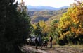
The National Park of N. Pindos consists of four distinct anthropogeograhical units. The villages in the west part of the Prefecture of Grevena, Konitsa, Zagori and Metsovo. In the passing of time, the relationship of man and nature shaped the area in such a way that the natural environment and the culture comprise an unbreakable entity. The landscape, the rich mosaic of vegetation and fruiting plants was formed also by the cultural particularity and the different exploitation and land use ways of the nomad farmers. Under these conditions, the existence of the bear in the mountainous range of N. Pindos is not incidental. The presence of the bear today, as well as of the other species of the wild fauna, comes along with the zone of nomadic farming, and more specifically the summer zones, during the period 1850- 1950.
The conservation of a large number of farming animals, alive or dead, has been the basic food source for the large carnivores (wolf- bear).
Agriculture has also played an important role in the conservation of many fauna species, with the small mountainous cultivations that offered additional food, for example, to the bears.
The arch stone bridges, the sheep-pens, the small cultivations, the orchards and the vines, together with the large mountainous bulge that encompasses them, compose the scenery of N. Pindos that changed only a bit in the passing of time, as it still conserves an important extent and naturalness. The little churches and the monuments found scattered in the area were, in the previous century, the marks that led the drivers and the caravans travelling towards the large commercial centres. The absence of human activity during the critical, for the survival of the bear, 7month period from November to May helped its conservation. Furthermore, in the 5month period from June to October, the type of human activity let the bear find movement ways, vacant areas and shelter. Nature was left without obstacles in its own work and in return it helped humans to survive in difficult periods. The systematic shrinkage of the population that started in the middle of the 20th century changed the conditions.
The inhabitants that were left are, in the majority, very old and they don’t work in productive activities. Land use has changed and now only 1% of the total area is occupied by agriculture. However, the forests remain in the same percentages, 58% in 1991, in comparison to 60% in 1961. In the long-term, the demographic shrinkage, the social and financial recession, foresees deep cuts and ruptures in the cultural context and as a result, impacts in the mountainous ecosystems.
Important Landscape Elements
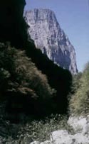
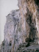
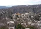
Vikos Gorge: It was created by the intense geological shuffles. It is supposed to be one of the largest and most impressive limestone gorges of Europe. Its length is 12 Km, its average width is 200m. and its maximum depth is 1200 m. It is an important shelter for raptors and the bear. Another also impressive landscape is Aoos Gorge.
Vikos gorge, Aoos gorge and the mountainous bulge of Timfi have been declared as a National Forest Park in 1973. At least 50 forest tree and bush species have been recorded inside the boundaries of the park. Rare, and unique for our country, endemic plant species, such as Valeriana epirota, Centaurea pawlovskii, Lilium cariolicum, Ramonda sebrica, etc. are growing in the Park and attract the attention of scientists from all over the world. The historical and cultural heritage of the area is also especially important.
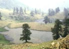
Valia Kalnta: Dense forests of Black Pine, forests of centenarian white pine, important fauna, special topography, presence of rare rocks where special vegetation grows, gorges, valleys and streams characterise this unique, in naturalness and biological value, area that comprises part of North Pindos. Valia Kalnta (Hot Valley in a local dialect) has been declared as a National Forest Park in 1966. It comprises an important seasonal biotope for the brown bear and for some raptors like Neophron percnopterus, Gyps fulvus, Aquila heliaca, Aquila chrysaetos, Falco biarmicus, as well as eight woodpecker species. The protection status in the core of the park is extremely strict.
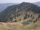
Flegkas Lakes: In Valia Kalnta there are two mountainous lakes- known also as twins- on the top of Flegka, at an altitude of 1960 m. At this altitude, only white pines grow and thus comprise a special natural monument.
Drakolimni Tifmis: Relic of the ice age, one of the 3 that were left in North Pindos. Its depth reaches 200 m. and it is assumed that it communicates with the natural groundwater network of Timfi.
Mixed Forests, Valia Kalnta: They appear in the whole mountainous zone, at an altitude higher than 800 m., and comprise an important biodiversity reservoir. They were threatened by the forest fires (summer 1993, summer 2000) and proved to be more resistant than the pure coniferous forests.
 From the left: Vikos Gorge, Valia Kalnta, Flegkas Lakes
Protection Status
The area of North Pindos was declared recently (and after long-term efforts, especially by the side of NGOs) as a National Park with the name “National Park of N. Pindos” (size: 2000 sq. Km. approx.) according to the law-framework for the environment 1650/86. The Administrative body of the Park is its Management Authority. The aim of the creation of National Parks and Management Authorities is to safeguard the natural heritage and to conserve the ecological equilibrium through the special management of those areas.
A system of zoning is usually applied, when dealing with large, in size, areas, which relates to a gradation of protection statuses in the interior of the area. The designation of the protection zones is done according to the conservation of the natural environment, but also taking into account the conservation of the productive activities that already exist in the area.
The activities that are usually permitted inside the boundaries of the National Parks are mostly traditional, while environmental education and nature-friendly activities are promoted.
For the National Park of N. Pindos, the zoning categories that were proposed according to the law-framework for the environment 1650/86 and were recently approved according to the Common Ministerial Decision, as well as the permitted activities, are the following:
Area of nature protection: where scientific research, guided visits, conservation and improvement of paths are permitted, while every new road creation or enlargement is strictly prohibited (it includes: Vikos gorge, Aoos gorge, eastern slopes of Timfi).
Area of ecosystems and flora and fauna species conservation: only traditional activities (apiculture, agriculture, farming, forestry with specifications, scientific research) are permitted (it includes: peripheral zones of the two forest parks, as well as the intermediate area, Mitsikeli, Aoos valley in Laista).
Peripheral zone of the National Park: traditional activities, development of mild recreational forms (it includes: Grevena area, west Zagori and the area north of Konitsa).
Zone of sustainable management: all the aforementioned activities are permitted, as well as forest exploitation according to specifications. The zone of sustainable management also includes, apart from the productive forests, the residential units, where all the relevant activities are foreseen. This zone plays the role of a starting- point and an information pole for the visitors.
Dangers and Threats
The gradual abandonment of the agriculture and the desertification of the countryside, after the war, had as a result the initiation of a rectification course of the forest ecosystems of N. Pindos. This fact, however, was reversed when the intensive exploitation of the natural resources started, with openings of motorways, intensive logging, bad management of the water resources and the use of heavy machinery.
Today, the area of N. Pindos and the National Park faces threats that possibly in the next years threat to change dramatically its picture if they are not confronted on time and based on a plan. The most important threats seem to be:
Wastewater- Garbage
Toxic substances that are used or released by household products (detergents, agricultural chemicals, petrol by-products) pollute the potable surface water. The garbage exist in open air sites and thus comprise an attraction pole for the wild fauna, which in turn adapts its habits on lower quality food sources and gets used to taking human-made food. Due to their approach to inhabited areas there is a high risk of their direct killing by poachers or producers that their flocks have already been harmed. Quite important is also the danger of infectious illnesses (hepatitis) that threats the inhabitants of the settlements, as the disposal sites are usually inside the boundaries of the settlement. Today, it is estimated that there are more than 1600 illegal landfills in our country.
Solution: for now there is none. A confrontation plan for the problem is expected to be included in the management plan of the National Park.
Motorway network and large infrastructure works
The dense forest road network (that serves mostly forest exploitation) influences the naturalness and the conservation of the natural environment. Due to it, phenomena of landslide and erosion are already observed in many parts of the forest and of the relief, as well as degradation of the forest structure, loss of forest land, while the disturbance to the fauna from the uncontrolled movement and access of vehicles are the resulting negative impacts. Simultaneously, the excavations, the land reclamation and the polders create natural obstructions and change the image of the landscape.
The large motorway network (e.g. Egnatia road) and the hydroelectric works continue to threat the coherence and the natural integrity of the Park.
Solution: the specific regulation of the forest legislation permits the controlled use of the forest road network during the winter months with the placement of barriers. The environmental criteria of Egnatia road construction have been improved significantly in the part Ioannina- Grevena. Simultaneously, objections and continuous monitoring of the hydroelectric works take place (especially by the NGOs). Recently, the construction of a hydroelectric station was cancelled after the intervention of Callisto in the area of Mikrolivado SW of Valia Kalnta.
Forest works
The intensive forest exploitation (installation of construction sites, intense machinery use, large number of logging groups) that followed for many decades degrades the forest ecosystem and creates significant nuisance to the fauna. The forest now starts to be approached as an operational and alive ecosystem, while the competent bodies elaborate the new specifications plan for the forest management studies. However, their integration in the forestry has not been implemented yet while the practice of deforestation logging in the oak forests still remains a large problem.
Tourism
The new adventure tourism types that relate to the extended use of 4x4 cars and motorcycles, and generally the intense movement inside the forest/ mountainous biotope comprise a serious nuisance for the fauna of the area, while the planned development of a mass type tourism with huge infrastructure will influence negatively both the natural and the built environment. Quite often, indeed, mass tourism covers itself using the concept of ecotourism and becomes even more dangerous. Ecotourism, however, in comparison to mass tourism, does not exceed the carrying capacity of the protected area, while simultaneously promotes the protection of the natural environment, as well as of the cultural environment, and contributes to the conservation of the social web coherence.
Solution: In the framework of the National Park operation and the elaboration of a management plan, the compilation of a special management plan for visitors is provided

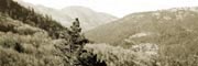

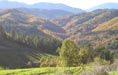
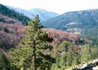
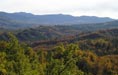 Forests at Grevena