Today’s productive uses
Today, Rodopi forest, the most productive forest of the country, constitutes the basic resource of the area, while 65% of the total area is dedicated to logging. 200 families of loggers live and work in the forest from May to September. The logging practices that are organised by the District Department of Forests, using the method of selective logging, provide more than 25% of the total Greek construction wood. It is, actually, a fact that the abuses have been limited significantly the last years, but many problems still exist.
However, the area, as well as the whole Prefecture of Drama, still remains agricultural. The marble and other small factories complete the productive scene of the area. One of the hopes of the local communities is the forthcoming visitors current.
The Boulgarian side, Trans-border activities.
From the tops of Rodopi, Fraktos at 1950 m., Tsakalos at 1814 m., or Koula (1606 m.), someone can see the inseparable continuity of the two sides of the mountain: the greek and the bulgarian. The borderline in the map seems so fabled from here, as it is in reality, as far as the bears and the golden eagles that traverse it is concerned. The mountains do not understand what borders mean, and the same counts for threats. That is why we, as an environmental organisation, give always priority to the cooperation with organisations from the “other side”: like when the mountain was threated by fragmentation due to the construction of the motorway between Exochi and the greek-bulgrarian borders, or when “Zoumperos”, a young male bear that was monitored using a radiocollar, decided to pass the borders. Without a passport, of course!
The Boulgarian side of Rodopi that accomodates more villages and towns, preserving a more agricultural character, gives us the chance for a “trans-border” tour, in places like Dospat, Trigrad, Borino, Siroka Luka, Smolyan and Smilian.
Rodopi Forests
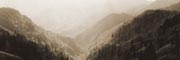
The wet climate, which is transitional from meditteranean to mid-european, as well as the relevant isolation, have led to an extended forest cover that reaches approximately the ¾ of the total area. However, it is not only the forest area that attracts the interest.
Rodopi mountain holds a key position in the eurasean zone: it is a crossroad between the east and the west, the continental midland and the Mediterranean zone. Therefore, behind the deep green of its mountains, an investigative look will discover a large variety of different vegetation types and plant formations.
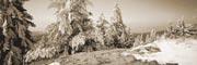
The lower slopes are covered by oak forests (Quercus pubescens and Q. frainetto to 800 m., Q. petraea to 1200 m.). Quite often they form mixed forests with other deciduous species, such as Carpinus orientalis. In altitudes higher than 1000 and 1200 m. dense beech forests (Fagus sylvatica) appear succesively, forest pine (Pinus sylvestris), but also red spruce forests (Picea excelsa), a north european species for which Rodopi comprises its southest spread limit and, of course, the only area of its presence in Greece. Between the aforementioned, we can also distinguish forests of the north european birch (Betula pendula), a species that is again rare for us, clusters of Pinus peuce, an endemic balkan species, as well as clusters of Alnus incana along the streams, a species also unique for Greece.
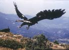
 From the left: chamois, Tetrao urogallus, Aquila chrysaetos and brown bear
Flora
The natural history of the area contributed also to the development and the conservation of a great diverse flora: since the age of ice, when the mountain that was not covered by ice became a shelter for species that disappeared from the broader geographical zone, till the 20th century, when its border position limited the productive uses in the area.
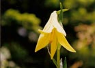
From the 1121 plant species and sub-species that we know that exist today in Rodopi, at least 7 are local endemic, meaning that they don’t exist anywhere else in the world. Between them is the famous Lilium rhodopaeum, the yellow lillium of Rodopi. Ten more species are Greek endemic and 80 more are Balkan endemic, while dozens of others find their southest limit of spread here. In total, more than 290 species and sub-species are considered as threatened, rare or important. That is why it is very important not to collect any individuals from whichever population.
Ecosystem types
This flora wealth is developed in a series of different ecosystems, from the dense forests to the mountainous grasslands, the riparian vegetation, and the abandoned settlements.
In between them, we can distinguish the acid bogs, holes of stagnant water with a small depth that accommodate layers of mosses aged thousands of years, other amphibious vegetation, as well as, a unique in Greece, insectivore plant, Drosera rotundifolia. The pollen that has been accumulated and conserved for thousands of years in the acid bogs, transforms them into an alive paleobotanic museum that holds the whole history of Rodopi vegetation. Their protection is a priority according to the Natura 2000 network. The three acid bogs of Rodopi, in Elatia, Lepida and Chaintou are some of the few in Greece.
The bear
Another reason for the incorporation of Rodopi areas in the Natura Network is the presence of a small but sustainable population of the Brown Bear (Ursus arctos), the second sub-species in Greece, after the one in Pindos. Approximately 25-30 bears live and reproduce in the broader area, finding a great variety of food in the extended forests, such as meadow grasses and fruits like wild cherries, wild apples, berries and acorns. It has been estimated that 88% of their food in Rodopi is plant originated, while the remaining 12% is comprised of ants and other animals.
The last years their coexistence with farmers seems to improve, but there are lots more that have to be done in order for the producers and the bears to get along better. Callisto systematically takes action in the direction of adopting prevention measures, such as electric fences and Greek shepherd dogs, of pressurizing the competent bodies for the renewal of the funding programs for prevention measures, as well as of the relevant briefing of the farmers.
Chamois and other mammals
A few visitors will have the strength to walk on the tops of Rodopi in order to find traces of the chamois (Rupicapra balcanica). Small flocks of this mountainous antelope continue to find refugee in the high and steep forested or rocky slopes.
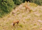
Rodopi conserves populations of all the large mammals of the Greek mountains: from the river otters (Lutra lutra) –“indicators” of the clean streams of the area- to the few dears (Cervus elaphus) that comprise the only remaining population in Greece. Together with them, the wolves, the wild boars, the roes and the wild cats leave their traces in the paths, opening a new exploration field to the attentive visitor.
Bird populations
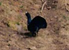
Tetrao urogallus is the most famous representative of the bird fauna in Rodopi. This is very fair, as it is a fabulous forest bird that reaches 90 cm (the male), while the Rodopi population is the largest in Greece and the southest in Europe. The scenery of birds is completed by the rare Bonasia bonasia, the golden eagle (Aquila chrysaetus), as well as a variety of woodpeckers, with the most important being Dryocopus martius, the largest and the rarest of all ten woodpecker species in Greece. It should be noted that only in Rodopi all the ten species have been observed living together in the same area.
Nestos- Waters
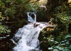
The wet climate and the extended forests of the area create a large network of small and bigger steams, most of them conserving water for the whole year. Vathirema, Arkoudorema, Diavolorema or Farsino, conserve a rich riparian vegetation and a significant fish and amphibian fauna, and supply water to Nestos or to its artificial lakes.
This large river has its source in the mountain Rila in Bulgaria and traverses approximately 234 Km in total, of which 130 Km are in the Greek territory, until it discharges in the sea, opposite of Thasos island, creating a delta that at a time accommodated one of the largest riparian forests of Europe, Kotza Orman. Today, only a small area is conserved, where important lagoons like Vasova and other ecosystems are found.
The biggest part of the river that traverses Rodopi has been transformed in a water reservoir, due to the hydroelectric dams in Thesauros and Platanovrisi, which create artificial lakes of 45 and 11 Km length respectively. A huge infrastructure used for power production and irrigation, with many impacts both to the riparian environment and its coherence with the mountainous ecosystems, and to the delta.
The abandoned settlements
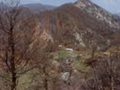
The human life and work that existed for centuries, until the violent reversals of the 20th century, left back obvious traces, even in the more isolated corners of the Rodopi mountains. The ruins of old settlements and orchards comprise today inseparable elements of the landscape with an ecological role. The cherries, the apple trees and the plums of the abandoned villages are today a valuable food source for the bear and other species of the wild fauna.
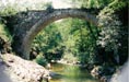
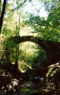
The old paths, many of which traverse dozens of the area’s streams through arch stone bridges, are still the mildest and most beautiful ways for visiting the forest. We cannot but compensate that beauty by taking care of their conservation and cleaning.
Traces
Broken branches of fruit-producing trees (for the baby, which follows its mother, to be fed). Inverted stones (for insect search). Broken tops of small trees (for the marking of the area). Footprints on the paths, usually more distinctive close to water halls and mud. Hair on the fat trunks by back scratching. Faeces (that can teach us a lot for the food habits of the bear, breaking down old myths): In the paths and the abandoned orchards of Rodopi, the attentive visitor can discover dozens of traces like the aforementioned, traces of the presence of bears or other animals. Thus, he/ she will learn to see behind the obvious, will experience the landscape in a way that goes further than the standards of the dominant consumerism view, will understand the relationships and the needs of a variety of species.
Human presence
Today, the permanent human presence continues in Rodopi at lower altitudes, near Nestos valley. Despite the gradual decrease of the population due to the internal or external immigration of the previous decades, we’ll meet there villages, such as Pagoneri, Potamoi, Mikromilia, Skaloti, Sidironero on the west, and Kariofito, Dafnonas, Stavroupoli and Pomakoxoria on the east. The area is mostly based on Paranesti, a mountainous, extended and under populated Municipality that includes villages, such as Mesoxori, Xagnanto, Tholo, but also Paranesti itself. Fortunately, we will not find here false “picturesque” and “ecotouristic” shops, but sincere hospitality, quality products and a society of people that fights to help their land.
Further down, we will meet the well-preserved and beautiful Stavroupoli, old central village of the area. From there and upwards, the west Pomakoxoria of Xanthi are spread, Kotili, Oraio, Dimario. Villages that despite the difficulties, with which they were punished for their diversity, remain active and alive, still keeping the activities that is difficult to meet anywhere else in Greece, like the needling of the tobacco leaves in Dimario and the water mill in Oraio.
Management, legislation, Callisto’s proposal
This unique mountainous ecosystem has remained for decades without a formal protection status, with the exception of the Virgin Forest of Fraktos, which was the only one that was lucky enough to remain uninfluenced by every human activity during the centuries.
Thanks to its special characteristics, six areas were included in the European Natura 2000 Network. Later on, we were led to the establishment of the Protected Area of Rodopi Mountain and its Management Authority (MA), where competent Ministries and services, local Authorities and environmental organisations, such as Callisto, are being represented.
The Management Authority of Rodopi Mountain (www.fdor.gr) is based in Mesochori in Paranesti. Temporarily, it is accommodated in the Town hall of Paranesti (tel: 25240 21030).
Despite this positive progress and the persistent efforts of the local community, Callisto and other bodies, the truth is that the area remains without a definitive delineation and clear management status, without scientific monitoring and, even more, without specific protection actions and efficient guard. The efforts of the MA, in cooperation with the Forest Department and other bodies, can give a solution to these problems in the near future. We continue, though, to insist on the stable and efficient protection of the area with the support of the public services.
Very recently, the plan of the Common Ministerial Decision has been promulgated for the characterisation and the zoning of the area. Callisto fights for the declaration of Rodopi mountain as a National Park, as it really deserves it. In the future, we would like to see it being declared as a Trans-border Park, of European and international importance.